Serviços de Topografia

Realizamos consultoria em regularização de imóveis e serviços de agrimensura com tecnologia avançada.

An aerial view of a construction site with a foundation layout. The site is surrounded by areas of dirt and soil, with a paved road running along one side.
Consultoria em Regularização

Esclarecemos dúvidas sobre regularização de imóveis urbanos e rurais de forma eficiente.
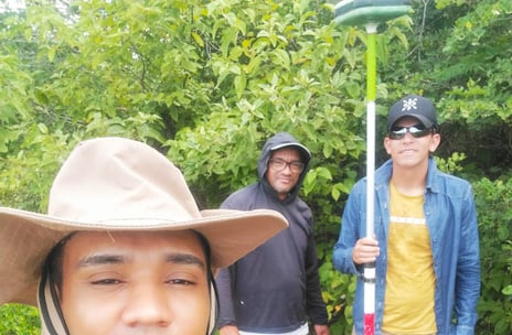
Medição de Terras

Utilizamos GPS GNSS e drone para medições precisas em terrenos urbanos e rurais.

Serviços de Obras

Execução de linhas de transmissão, estradas e saneamento básico com alta qualidade.

Projetos Topográficos

Serviços de agrimensura e consultoria para regularização de imóveis.
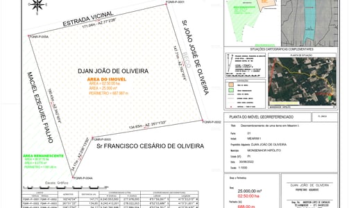
Medição de Terras

Levantamentos precisos com GPS, estação total e drone.

Consultoria Imobiliária

Apoio na regularização de imóveis urbanos e rurais.

A lush, green landscape features a field of grass with scattered trees in the background under a partly cloudy sky. In the mid-ground, there's a yellow excavator parked, suggesting ongoing development or construction activities. The foreground includes a modern, white building corner with a sloped roof of another structure visible.
An aerial view of a neatly divided landscape with a large section of lush green fields occupying the upper portion, marked by faint, parallel tracks likely from agricultural machinery. Below, a smaller area of brown, tilled soil is visible, indicating a transition between cultivated and uncultivated land.
Obras de Infraestrutura

Serviços em linhas de transmissão, estradas e saneamento.

Levantamentos Aéreos

Utilização de drones para mapeamento e levantamento de dados.

A person wearing a high-visibility safety vest and a beanie stands outdoors, operating a theodolite mounted on a tripod. The background includes the facade of a residential building with balconies.
Serviços de Agrimensura

Consultoria em regularização de imóveis urbanos e rurais.

200 R$

An aerial view of vast agricultural fields organized in a grid-like pattern. The fields are divided by straight roads and irrigation channels, creating rectangular sections. The landscape appears flat, with variations in color indicating different crops or land usage.
An aerial view of expansive farmland divided into various rectangular and circular plots. The fields vary in color and size, indicating different stages of cultivation or use. Sparse buildings and farmhouses are scattered across the landscape, connected by a network of dirt roads. The land appears dry and barren, possibly indicating an arid climate.
Medição de Terras

Levantamentos com GPS e tecnologia de drones disponíveis.

750$

Consultoria Imobiliária

Soluções completas para regularização de propriedades rurais e urbanas.

Obras de Saneamento

Serviços de obras como estradas e linhas de transmissão.

800$

An aerial view of an agricultural landscape with rectangular plots of land, some filled with water indicating rice paddies. There are various shades of green vegetation and a few scattered small structures. A dirt road runs through the scene, with trees and bushes lining the plots.
An aerial view of a vast landscape with a mixture of cultivated fields and undeveloped land. The foreground showcases a large excavation site with visible construction vehicles and dirt tracks. Surrounding the site are lush green fields, with some patches of vibrant yellow. In the distance, the horizon is filled with more fields and a line of dense trees. The sky overhead is mostly clear with some large, fluffy clouds.
A landscape featuring a white building under construction situated on a red dirt plot, surrounded by lush green fields and rolling hills. In the distance, patches of greenery are interspersed with clusters of buildings, creating a rural setting.
Levantamentos com Drone

Tecnologia avançada para medições precisas de terrenos.

450$

Consultoria em Regularização

Apoio completo para a regularização de imóveis e terras.

600$

Serviços de Obras

Execução de obras de infraestrutura e saneamento básico.

500$